THE VILLAGE OF BONKLE, LANARKSHIRE, SCOTLAND
by Sandy McIntyre, a Scot.
(Sandy died 12 March, 1998 and the following has been compiled by Ian Glen from notes left by Sandy, and is dedicated to his memory)
Bunkle, Duns and origin of name Bonkle
Chronological History of Bonkle and surrounding area
Bunkle, Duns, and the origin of the name.
The Session Book of Bunkle and Preston Church, 1665 to 1690.
Presented for Berwickshire Naturalists Club, Hawick, 1900.
From this book are taken the various derivations of the name:
BONKLE BONKYLL
BONKILL BONKYLLE
BONKILE BUNKLE
BONCKLE BUNCLE
The Village of Bunkle, near Duns.
There is a village of Preston, on the A6112, on the A1 between Duns and Granthouse.
At Preston is Bonkyl Lodge. North from Preston the B6438 will bring you to the ruins of Buncle castle.
Bunkle church is just beyond Buncle castle ruin on a road branching off to the right on the B6438.
Bunkle wood is near to Preston.
East from Duns along the A6105 lies Chirnside. South along the B6437 takes you to Allanton. Nearby is the junction of the Whiteadder and Blackadder Waters.
Allanbank is near to Allanton.
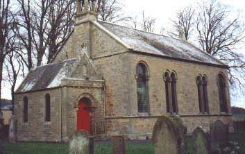
Bunkle church is still in existence. Rebuilt in 1820, it has 400 seats.
The new manse was built in 1846.
The old village of Buncle became disused around 1800 AD. It had been inhabited by joiners and weavers.
The meanings of the word Bonkle
a) BONA CELLA Excellent site for a warehouse or granary.
b) BON COILE Foot of the wood.
c) BON CILL Chapel at the foot of the ridge.
In 1066 AD when William the Bastard of Normandy invaded England, he brought with him many knights who were anxious to gain land. After the Battle of Hastings the Normans spread North. They took their names from the area they settled in, built castles, reared families, who in turn, grew up, then set forth to get their own land. So it was that a Norman knight came to BON CILL. He built two castles, one BUNCLE castle, the other BILLI castle (after BILI Ling of Northumbria) and styled himself BARON DE BONKYLL.
Alexander de Bonkill ( died 27/4/1300 ) had one daughter, Margaret, who in 1288 AD married John Steuart, 2nd son of the Steward of Scotland, who held the Lands of Daldowie and Allanton. There was a small keep or tower at Allanton and this was given to the son. When Margaret's retinue came to Allanton they found a BONA CELLA sited on a bank of the South Calder water. As she was Margaret de Bonkyll and they wished to retain the name, they constructed their dwelling close to the storehouses and present day BONKLE came into being. Margaret died in 1305. Both her son Robert Steuart and his cousin Alexander de Bonkyll fought alongside Bruce (DE BRUS) at Bannockburn. Bruce's ancestors had also come over with William (no longer the Bastard but the Conqueror). John Steuart himself died on the 22nd July 1298 AD at the Battle of Falkirk.
The Battle of Morranside, August 1385
In May 1385, Charles VI (1380-1422) of the house of Valois, and King of France, sent Jean de Vienne, Admiral of France, their top General and Fighter, to Scotland, accompanied by a fighting force of 26 bannerettes, 50 knights, 1050 men at arms, 150 horses, 200 pack animals, 80 suits of armour, 80 lances and 50,000 gold francs. This force was to be placed at the disposal of King Robert II of Scotland to help counter the English Army which would shortly invade Scotland according to the French spies in England.
On August 6th 1385, the English Army, composed of 9,144 archers, 4,590 men at arms, cavalry and pack trains, and supported by supply ships, marched into Scotland by the east coast route. They were led by Richard II (1377-1399) then 18 years of age, and he was accompanied by John of Gaunt. The Scots being forewarned had carried out a scorched earth policy and food was difficult to obtain. The main body of the English army continued along the coast towards Edinburgh, while a foraging force of around 1,000 set off for Lanarkshire.
In 1384 Buckingham and Lancaster had raided Lanarkshire but had been very badly mauled. As the foraging forces reached the Muir of MacMorran they were engaged in battle by Allan Steuart, (a vassal of the Black Douglas and married to one of his daughters), leading a mounted troop of around 600 men from his lands of Allanton and Daldowie. The English party were driven off with heavy loss and retreated back towards Biggar. Allan Steuart, who was then 63 years of age at was slain in the battle. He was buried in the chapel of Beuskaig of Beuskaig. His son, also called Allan, then collected what was left of the troop and went on to join Robert II army which was raiding and looting the west coast of northern England. He was knighted under the King's banner for his exploit. The French party, who were with the Scots army, were not pleased at this method of waging war but when some were taken to see the size of the English army they realised that the Scottish tactics were the only suitable ones, because the Scots did not have the resources to hold back, let alone defeat the English army.
But where arms were not sufficient, Alan Steuart's defeat of the foraging party caused the English army, after having sacked Edinburgh, to retreat back to England. Despite John of Gaunt's wish to go on and attack Fife, Richard II ordered a retreat because he could not bear to watch his army starving.
Reference Books:
The last Medieval Summons of the English Feudal Levy, 13 June, 1385 N. B. Lewis.
The Last Summons of the Feudal Army in England J. J. N. Palmer.
Cathkers - The field east of the battle.
Alcath - The field of Allan's battle.
Cath Burn- The battle burn.
Auchter Water - The river of Allan's battle.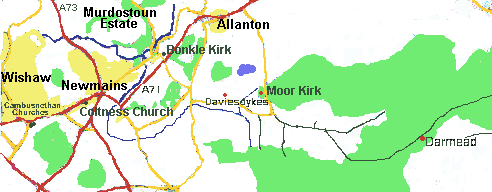
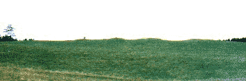
The name Morningside means in the East or the side on which the sun rises.
In the 13th Century map there was a farm called Morranside. On General Roy's map it had become Moranside. This at a later date was construed as Morn, short for Morning, and Morningside it became.
At one time it was said that it got its name because it was East of the battle. Unfortunately it was West.
Cathkers the field "East" of the battle was where armour relating to the battle was dug up. It was kept in Allanton House and finally shipped off to a museum in Edinburgh.
The present day Morningside Farm is nowhere near the Moranside of Roy's map (by a good Scots mile anyway).
Photo - Feb. 1999. 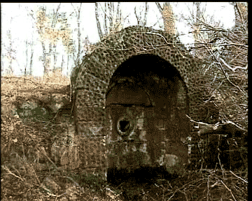
In 1813 AD Sir Henry Steuart had a fountain erected in the woods near the main Ayr - Edinburgh road and only a few yards from a small croft known as The Den. The fountain was fed by a spring and the water came out through the mouth of a stone lion head. Attached to the bowl into which the water ran was a cast iron cup. On the fountain is an inscription-
Allani Stevart De Allanton et daldvi, equitis banneretti viri egregii armis agerrimi ejusdem qui insigni pusna apud morningside clarus factue fons sacer
V.S.L.A Faciund C An 1813 H.S.
xi gradus distans hic a duce illo fortissimo.
ord survey maps 1859 and 1899
V - Votum - promise to a god.
S - Solvit - To fulfill.
L - Libenter (Libens) - Willingly.
A - Aedificium - Memorial.
A - Animo - Give life, to construct.
H.S. is Henry Steuart.
Gradus - is steps, but can in this translation mean generations.
Translation
D.M. - In memory of.
Allan Steuart De Allanton Et Daldvi - Allan Steuart of Allanton and Daldownie.
Equitis Banneretti - Knight of the Banner (to be knighted under the king's banner was then highest honour in the land).
Viri Egretti armis agerrimi ejusdem qui insigni pusna apud morningside - A man, famous for bearing arms in the field, who was outstanding in the battle near Morningside.
Clarus factus - A bright and singular deed.
Fond sacer - Sacred (to his memory) fountain.
V.S.L.A.V(Votum) S(Solvit) L(Libens) A(Aedificum) or A(Animo) - We have willingly fulfilled our promise to the gods to construct this memorial.
Faciund C an 1813 - Constructed in the year 1813.
H.S.XI Gradus distans hic a duce fortissimo - 11 generations being that period of time distancing us from that brave leader.
Promoters:
Mr & Mrs James McDonald.
Mr McDonald was manager of the Coltness Iron Coy's cement plant and stayed at No. 3 Allanton Road Bonkle.
Mr & Mrs William Russell.
Mr Russell was manager at the Coltness Iron Co's iron foundry and stayed at Auchter House.
Mr & Mrs Alexander Gillies.
Mr Gillies was minister of Bonkle Church and stayed at the Manse in Church Road.
The old ruin (No1 Allanton Road and known as Sanny Waddell's) next to No 3 Allanton Road was leased from the Allanton Estate. Money was raised at dances, bazaars, etc. and with the money a new roof was put on, new windows installed, water and sewage pipes laid, and the pavilion was ready for use. Two courts were built and the tennis club was in business. Games were played against Wishaw, Carluke, Bellshilll, Mossend, and the big one was played against Newmains. Sadly by 1928, when I left, the courts were on their way out.
Report by Mrs Janet Topping (Jessie Allan)
St Petersburg, Florida, USA (1985)
(She died in may 1991 aged 92.)
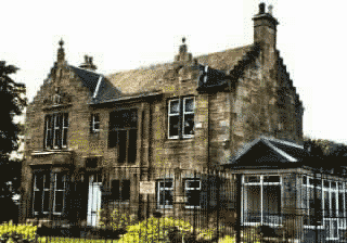
Bonkle is a small village, in the Lanarkshire area of Strathclyde Region of Scotland. It is within the Parish of Cambusnethan. It is bounded on its Northern side by the South Calder Water, on its Eastern side by the Woodypoint Estate, on its Southern side by the Bonkle bypass, the A71 Road from Edinburgh to Ayr, and on its Western side by the Auchter Water and a small stream, the Cath Burn which runs below the A71. The Auchter meets the South Calder Water at the foot of Bonkle Brae at the head of which stands Auchter House built in 1886 on the site of the old village of Auchter Bridgend. It is seen on the o/s map of 1859 and in 1770 was in the ownership of Alexander Brownlie. There was a wooden bridge across the Auchter shown in a map of 1654. It was replaced by the present stone bridge.
On the Northern side lay the Motherwell Council depot, which housed machinery for grass-cutting of fields, road verges, and gardens. Further to the East is the football park, once known as Bonkle Heugh, and latterly as the Gowan Park. This field is bounded on its Eastern side by Murdostoun Road which crosses the South Calder Water by a stone bridge built in 1817, one year before Garrion Bridge was built over the River Clyde. In the centre of Bonkle was a wooded roundabout from which Murdostoun Road, Allanton Road, Church Road, and Bonkle road radiate. It is sometimes called Bonkle Cross. On Murdostoun Road was the old Smithy House though the smithy has been demolished and a bungalow built on the site of the smithy yard. On Allanton Road is No 1, No 1 A, and No 1 B. The original No 1 was a ruin known as Sanny Waddell's but it was taken over in 1919 by Bonkle Tennis Club which ran until the outbreak of the war on Sept. 3, 1939. The present No1 had been built before the 1914 war and took over the No 1 number. When the Tennis Club site was sold, the old Tennis Club house became 1A and a new house built on the site became 1B. 1A was converted from the old Club House to the present day house. The reason the houses had to be numbered that way was because Nos 3, 5 and 7 were in existence, having being started in 1815 and completed in 1817. The date is above the door of No 3. They are known as the Waterloo Cottages after the Battle of Waterloo fought in 1815 in which many local people took part.
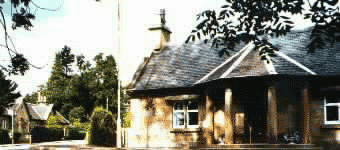
In Church Road we have No 1 known as The Pillars after the round stone columns which support the roof over the front door. This building was the Old Toll House and built in 1811 to draw revenue from the new road from Bonkle to Allanton. The old road was covered by Allanton Loch, which was constructed by Henry Steuart of Allanton House. He had a new mansion built by Graham Gillespie on 1785-1786 and the loch, new driveways, the West Lodge, and the North Lodge, plus the new road were all part of a grandiose landscaping scheme in which trees played no small part. In 1785 new cottages were built in Church Road. Nos 10 to 24 were all re-faced from 1890 to 1903. At the rear of No 20, the date 1792 can be seen on a window lintel. The date 1785 is on the gable end of No 10 but is covered with roughcast. The church and manse were built in 1818 and the church totally rebuilt from the founds up in 1878, the same year as Coltness church was built in Newmains. The Bonkle congregation, during the period of rebuilding, worshipped in the school on Murdostoun Estate. The school later became a sawmill and is now a barn. The Woodypoint estate occupies part of the old Allanton Estate, and the new house built over part of the old loch now overlooks the new Woodypoint Loch with its wooded island. Jim Foy was taken prisoner by the Japanese during the 1941-45 war, and when it ended he was returned to Australia with other prisoners by boat. It docked at Woodypoint, North of Brisbane. When Jim took over part of the Allanton Estate to run a tea-room, he called it Woodypoint. Bonkle Road and Allanton Road were originally the old A71 but this number was transferred to the Bonkle by-pass opened in 1974. Bonkle Road enters Bonkle over the Auchter Brig. Bonkle road had Bonkle's only shop. A brick building replaced a former wooden building which had been erected at a site opposite in 1932 by a Mr White and he moved from No 10 Church Road to Allanton in 1934. George Elder bought the shop and moved it to its present site in 1938. Hannah McKeating took over from George Elder in 1955 and the shop was sold to Betty Paton in 1985. She still owned it in 1992. This has now been replaced by housing.
A Scout hut built in 1934 has since been demolished, the site now being occupied by No 6 and 8 Church Road. The Scouts, started in 1917, were based in the new church hall built in 1991-1992. (They moved to Allanton church but have been discontinued.)
 The first known name for the Bonkle area was Dunaninbher (the height or the fort above the meeting of the waters). It was possibly a small type of fort, maybe stone age, and where the local inhabitants retreated to for safety from marauding bands. The bend in the South Calder gave a good area for keeping livestock, and building storehouses. As years went past the monks at Garrion had a storehouse there, and in the early 1800's there was a small farm called Haughbank. In the 1860's its ruin was used by a religious sect for changing into white robes before being baptised by total immersion in the South Calder. The Pool they constructed can still be seen opposite the boundary between Auchter House and the County Depot. When Margaret de Bonkyll, daughter of Baron de Bonkyll of Bonkyll Castle near Duns, married John Steuart in 1288 she came to stay at Allanton Keep. Her retinue set up a small village to the west of the Keep. The reason for this was to stop any of them deserting back to their own village. Alan Steuart had a village built on the east of the Keep to keep his retainers from deserting back to their village of Daldowie. Thus Bonkle and Allanton came into being. Throughout the years, the old fort fell into disuse, and we know that in 1654, a village called Auchter Bridgend stood on the site. This village too was knocked down and today Auchter House stands on the site of the old fort.
It is not difficult to see how Bonkyll and Bona Cella became the present day Bonkle.
The old quoiting ground and later football field now occupied by 276 and 278 Bonkle Road were the home of Bonkle Star and Bonkle United, before the present field, which was bought at the sale of Allanton Estate in 1932, came into use. Bonkle Athletic used it during the 1939 - 45 war and from 1943 to 1980 it was the home of Bonkle Youth Club, who won the Scottish Amateur Under 16 cup in 1969, and numerous other trophies in youth football.
Meadowfield Place, Brownhill View, and Cairney Place make up the remaining streets.
Cromwell crossed the old wooden bridge after leaving Allanton Keep and going to meet his troops at Crossford. This was after the incident of the "Little Captain".
Chronological History of Bonkle and the Surrounding District
(from notes left by Sandy McIntyre with some additions by Ian Glen, 1998)
|
Date |
|
|
125AD |
Oldest map drawn by Atolemy, the Greek, shows Coria (Carstairs) capital of the Damnonii Tribe and Colania (Lanark) its main fortress. |
|
150AD |
Roman road (iter) went past present day Bonkle on its eastern side. This went from Belstane (Carluke) to Castlecarry over the old ford known as Watersplash. |
|
700AD- 800AD |
Blackband ironstone being taken north by Picts from around Hartwood and used for body paint and iron weapons. |
|
1000AD 1100AD |
Small towers with flat roofs being built. (52ft high, 24 ft wide, walls 10ft thick) Castleriggs (Hartwood), Castlehill (between Bonkle and Allanton). Allanton Keep and Murdostoun Keep also built. Hallbar Tower (Braidwood). |
|
1153AD |
Kambusnaythan - Nethans Bend - recorded. |
|
1288AD |
Margaret, daughter of Baron De Bonkyll marries John Steuart of Allanton and Daldowie. Bonkyll is situated near Duns and a small village built for her retinue near Allanton Keep was called Bonkil now Bonkle. Haughbank is on pre-roman site called Bonna Cella by Garrion Monks 700 - 800AD. |
|
1290AD |
Alisaundre De Bonkyll name appears on letters from Scottish nobles to Edward I. |
|
1296AD |
Scott marries Murthock's daughter and inherits lands of Murdostoun and Hartwood. |
|
1298AD |
22nd July - John Steuart slain at the battle of Falkirk. |
|
1314AD |
Robert Steuart fought at the Battle of Bannockburn. |
|
1384AD |
Buckingham and Lancaster raided Lanarkshire. |
|
1385AD |
Richard II and John De Gaunt invade Scotland. Part of their force defeated at Battle of Morranside (Morningside). Alan Steuart killed in Battle and buried at Chapel of Beuskaig (Beuskiag, Beuscaig). |
|
1420AD |
Scott of Murdostoun in half exchange with Inglis of Branksholm. |
|
1421AD |
Alan Steuart obtained tenure of estate (Allanton) from Arbroath Abbey. |
|
1446AD |
Scott of Murdostoun in full exchange with Inglis of Branksholm. |
|
1484AD |
Garrion Tower rebuilt in its present form. |
|
1540AD |
George Wishart visits Allanton Keep. |
|
1563AD |
James Steuart at Battle of Langside helped to defeat Queen Mary. |
|
1572AD |
Thomas Inglis of Murdostoun killed Darnley (King of Scots) by blowing him up with gunpowder. 1591AD |
|
1591AD |
Old tower at Allanton rebuilt. |
|
1635AD |
Map of Scotland (made in Holland) showing Lanark, etc. |
|
1638AD |
National Covenant of civil and religious liberties drawn up. |
|
1641AD |
Solemn League and Covenant drawn up. |
|
1650AD |
Cromwell visited both Murdostoun Keep and Allanton Keep. Crossed Auchter on wooden bridge at Bridgend. |
|
1660AD |
Charles II imposes Episcopal form of church government on Scotland leading to worship at open air conventicles (Darmead). |
|
1662AD |
Kirkstyle (Carluke) composed of 1 church, 1 manse, and 4 cottages. |
|
1672AD |
Inglis up before kirk session at Shotts for drinking, swearing, running a rapier through brother's arm and setting fire to his father's door. |
|
1679AD |
Covenanters fight at the battle of Bothwell Bridge. |
|
1689AD |
Preacher James Renwick hung for preaching at conventicles. |
|
1737AD |
12 July - Congregation formed at Daviesdykes. |
|
1740AD |
"Moor Kirk" completed and occupied. |
|
1773AD |
Hyndford Bridge built. |
|
1775AD |
Start of building of Bonkle cottages, first finished 1785. |
|
1780AD |
Moor Kirk replaced with a larger kirk with slate roof. |
|
1788AD |
Allanton mansion built by Gillespie Graham, North and West lodges built (only North lodge remains today). |
|
1792AD |
Stone cottages (dressed) finished building at Bonkle. |
|
1798AD |
Survey shows large quantities of coal and ironstone in area. |
|
1794AD |
New road being built on south bank of River Clyde. |
|
1800AD |
"New Lichts" and "Auld Lichts" splits moorkirk congregation. |
|
1802AD |
Shotts Ironworks formed. Iron blast furnaces built. |
|
1803AD |
Major General James Hamilton, Laird of Murdostoun, dies. Buried at Shotts. |
|
1813AD |
Fountain built in Allanton Estate. |
|
1815AD |
Lt. Colonel James Inglis Hamilton (born James Anderson at Tayantroga, America) killed leading charge of Scots Greys at Waterloo. |
|
1817AD |
Murdostoun bridge built, Garrion bridge built. No 3 Allanton Road built. |
|
1818AD |
Bonkle Church built on present site. |
|
1836AD |
Darmeid monument built. |
|
1837AD |
Coltness Iron Company formed. |
|
1878AD |
Bonkle Church rebuilt, Coltness Memorial built. |
|
1886AD |
Auchter House built. |
|
1887AD |
Mary Slessor visits Bonkle. |
|
1890AD |
Bonkle Church becomes United Free Church of Scotland. Population of Auchterhead Muir = 950 |
|
1927AD |
Blast furnaces at Coltness Iron dismantled. |
|
1932AD |
Allanton Estate split up and sold. |
|
1933AD |
Scout Hall built. |
|
1935AD |
Start of building of Department of Agricultural Small Holdings at Cathburn and Sharnotshields. |
|
1937AD |
Meadowfield Place built. Bi-Centenary of Bonkle Congregation celebrated. |
|
1947AD |
Nationalisation of coal industry. Blast furnaces at Shotts closed. |
|
1963AD |
Start of building of Brownhill View. |
|
1964AD |
Charge of Allanton Mission transferred to Calderhead. |
|
1977AD |
Cairney Place built. |
|
1979 |
Bonkle Church is linked to Coltness Memorial Church. |
|
1984AD |
Last pit (Calderhead training centre) closes. |
|
1991AD |
New church hall opened. |
|
|